Beta · AI experiment for Swiss pilots

Which spot is flyable over the next few days?
The thermal forecast for Swiss launch sites.

3-day forecast for 494 Swiss launch sites — ranked per day, explained in plain language, from first flights to XC. Free, no credit card.

  • 494 Swiss spots
  • 5 weather models aggregated
  • AI rates, physics calculates
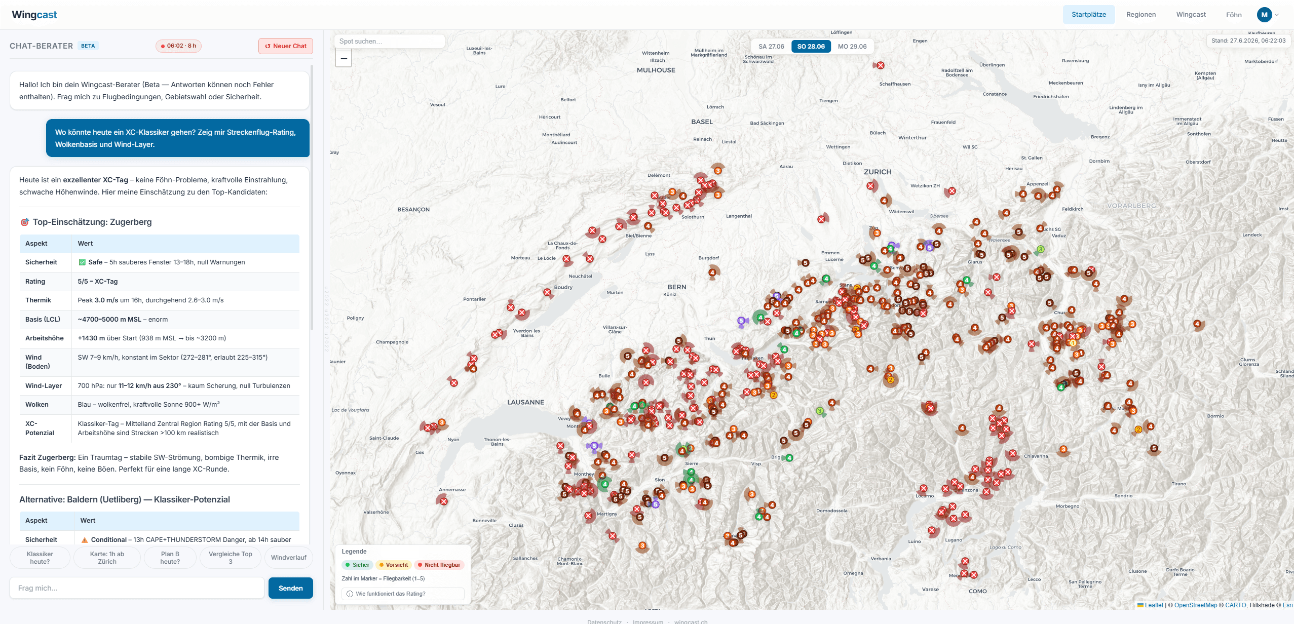
Wingcast app dashboard: chat adviser on the left, map with all 494 Swiss launch sites on the right, coloured by rating
Live in the app · 494 launch sites, coloured by rating

Thermal forecast Switzerland, Friday 30 October

Thermal forecast Switzerland

Today, Friday 30 October

In ICON-CH1/ICON-D2, Switzerland is under high pressure (1024.1 hPa). Over the day (06:00–22:00) pressure stays about the same (-0.2 hPa).

Model values Switzerland

Base
2000–3700 m
Climb
0.6–1.6 m/s
Upper wind
↙ NE moderate
Pressure
1024 hPa
Model values for three days

Updated 05:58, fresh every morning

More detail for your launch site

This page shows the values for all of Switzerland. The app gives them for each launch site, hour by hour: wind at launch and aloft, thermals and cloud base. Free, no credit card.

See the details in the app

Forecast generated automatically from weather models, without guarantee. Not a flight weather briefing, not a warning, not a recommendation to fly. Whether and where you fly is your decision alone.

Sound familiar?

Saturday, 6:30 a.m.
Where should today's flight be?

You check windgrams, you look at weather models, you compare webcams. 45 minutes later you have plenty of data — but still no clear answer as to which spot is the right one this week.

To check
Wind
Slope wind, valley wind, upper wind
To check
Thermals
Trigger time, strength, cloud base
To check
Safety
Foehn, front, lee
To check
Spot choice
494 launch sites, one day

In the end you only want to see one thing quickly: which spot is flyable today — and which is not.

Wingcast ranks the spots per day, with the reasoning in plain language. You take the assessment as a starting point, compare it with your own sources and decide for yourself.

From weather to Cast

How is the thermal forecast produced?

Every morning Wingcast calculates the thermal forecast three days ahead for 494 Swiss launch sites. Weather models and atmospheric physics first, only then does the AI rate. No black box.

  1. 1

    Data

    Read in weather models

    ICON-CH1 (1 km) and ICON-CH2 (2 km) from MeteoSwiss, ICON-D2, ICON-EU and GFS — aggregated once each morning via Open-Meteo, for the whole day.

  2. 2

    Physics

    Compute the atmosphere

    Thermal cloud base (parcel method with inversion detection), foehn detection (north–south pressure gradient, upper wind, humidity signature), gust decay over the terrain, cloud holes — deterministic in code, without AI.

  3. 3

    AI

    Analyse and rate

    On the basis of the computed physics, the AI analyses and rates safety and suitability for each spot. The reasoning comes in plain language — wind, thermals, time window.

Briefing

Updated 05:42

Analysis chain

  • 1Situation
    1024 hPa · high · rising
  • 2Fronts
    no front
  • 3Foehn / Bise
    no foehn
  • 4Upper wind
    regionally as average
  • 5Stability
    partly unstable
  • 6Thermals / cloud base
    good climbs
    Expectation
    High → subsidence, capped base
    Data
    Base 2600 mClimb 2.4 m/sSun 10–16h 80 %
    Verdict
    Exactly what the data show — subsidence under the high caps the base, climbs stay strong.
  • 7Sun / cloud
    as expected
  • 8Models
    one open point
  • !Warnings Switzerland
    thunderstorms from 16:00
Each block reads the situation like a pilot: the expectation from the synoptic pattern first, then the forecast data against it, then the verdict as a pill.

Example data — real values in the app at app.wingcast.ch.

Get started · about 60 seconds

Magic link, regions, off you go.

Sign-up runs on app.wingcast.ch. We store only your email address and the regions you choose — nothing else.

Create account
  1. 00:00Step 1

    Enter email

    The magic link arrives immediately. No password, no credit card.

  2. 00:30Step 2

    Choose regions

    e.g. Bernese Oberland, Valais, Eastern Switzerland. Changeable at any time.

  3. 01:00Step 3

    Read the Cast

    3 days, ranked by flyability, with reasoning for each spot.

FAQ

What pilots often ask.

Your question not listed? Write to info@wingcast.ch — the answer comes directly from us.

01What is Wingcast?
Wingcast is a free AI flying-weather app for Swiss paraglider pilots. It aggregates five weather models via Open-Meteo (ICON-CH1 at 1 km resolution and ICON-CH2 at 2 km from MeteoSwiss, plus ICON-D2, ICON-EU and GFS), computes classic atmospheric physics from them deterministically in code (thermal base, inversions, foehn detection, gust decay), and only then lets the AI analyse and rate safety and suitability for each spot. 494 Swiss launch sites are ranked automatically by flyability for each day, together with reasoning in plain language — wind, thermals, foehn situation, lee risks. Instead of digging through weather models for 45 minutes, you see in 30 seconds where it is flyable today or over the next few days — and why. Sign-up by email and magic link, no credit card, no trial counter. Optionally an email Cast arrives at 06:00 on the weekdays you choose. Wingcast is decision support for pilots, not a decision maker — the final decision at the launch site is yours.
02Is there a free thermal forecast for Switzerland?
Yes. Wingcast is a free thermal forecast for Switzerland: for 494 launch sites it calculates three days ahead every morning when the thermals trigger, how high the base sits and how strong the wind blows. The basis is high-resolution weather models, among them ICON-CH1 at 1 km resolution from MeteoSwiss. The physics runs deterministically in code: thermal base by the parcel method with inversion detection, foehn detection via the pressure difference Zurich–Lugano, gust decay over the terrain. Only on top of these values does the AI assess each spot and write the reasoning in plain language, for example: Niesen 11:00–14:00, wind 8 km/h south, thermal base around 2400 m, foehn tendency from 14:30. For each day the spots are ranked by flyability. Wingcast does not replace your usual sources, it makes the pre-selection – the decision at the launch site is yours. Free, no credit card.
03What does signing up cost?
Currently nothing. The forecast for regions, the spot rating for each of the 494 launch sites and the weekly briefing are accessible without a credit card and without a trial counter — you only have to sign up. If anything changes about the model, we'll say so openly before we switch.
04What doesn't work yet in the beta?
Honest answer: quite a bit. Wingcast is beta — individual launch sites are still missing from the data set, the stored launch direction may not be entirely right at some spots, and occasionally there are functional bugs or outages. We work on it continuously and prioritise according to what the beta community reports. Missing a spot, a launch direction that doesn't fit, a function that plays up? Write to us at info@wingcast.ch — a short note is enough, every report helps.
05What is the advantage over my current sources?
Wingcast doesn't replace them — it makes the pre-selection for you. Instead of comparing models and webcams for 30 to 45 minutes, you get a ranked list of the best spots for the coming 3 days in 30 seconds. The fine-tuning you do as usual with the tools you trust.
06What is foehn — and why is it dangerous for paraglider pilots?
Foehn is a warm, dry downslope wind that forms when air is forced over a mountain ridge, drops its precipitation on the windward side and sinks down warmed on the lee side. For pilots foehn means: high wind speeds aloft, strong turbulence in the lee of the mountains, rapid weather changes. Wingcast detects foehn situations via the pressure gradient between Zurich and Lugano, combined with the upper wind at 700 hPa and the humidity signature — the same indicators MeteoSwiss uses for its foehn warnings. When foehn is active, affected spots are automatically downgraded, with a note in plain language. More background: meteoschweiz.admin.ch/wetter/wetterphaenomene/foehn.
07Do I learn something while using it?
Yes. Every rating comes with reasoning in plain language — for example: Niesen conditional today, because foehn tendency from 14:00 → lee risk, safe slot 11:00–13:30. Over the weeks you recognise the patterns yourself — when foehn arrives, how inversions slow the thermals, where lee is to be expected. We don't want to replace your understanding of the weather, we want to speed it up.
08How accurate is the forecast — and what does the AI actually do?
We aggregate five weather models via Open-Meteo: ICON-CH1 (1 km) and ICON-CH2 (2 km) from MeteoSwiss for Swiss topography, plus ICON-D2, ICON-EU and GFS for large-scale situations and longer horizons. Classic atmospheric calculations run on this data deterministically in code: thermal base via the parcel method with inversion detection and terrain-calibrated zones, foehn detection via the north–south pressure gradient plus upper wind and humidity signature, gust decay over the terrain, cloud holes via reference points. Only on this data basis does the AI analyse and rate safety and suitability for each spot — it evaluates the computed physics and writes the reasoning. No magic, no hocus-pocus. In uncertain conditions we are deliberately conservative. We don't promise perfection.
09What happens after signing up?
You choose your regions in the app, confirm your email address and have immediate access to the forecast and the map. If you want the briefing, you set in the app which weekdays it should arrive on — the first email then follows on the next day you chose, at 06:00.
10Does this work on my iPhone?
Yes. The app runs straight in the browser, and the briefing is compatible with all mail clients. Apple Mail and Gmail support the interactive weekday tabs in full.
11Who is behind Wingcast?
A paraglider pilot from Zurich. Doing my own spot check I often couldn't see the wood for the data — windgrams, models, webcams, valley winds. Wingcast is my experiment: can AI help to process these volumes of data so that a clear basis for a decision ends up on the table? That is exactly what I'm testing right now — together with the beta community.
12What happens to my data?
We store your email address and the regions you choose. On this website the statistics tool PostHog and the Meta Pixel load only if you consent. In the app we measure without a cookie which functions are used — details in the privacy policy. We do not pass your email address on to advertisers. Unsubscribe at any time with one click.

Beta · build along

What you report goes into the next update.

Wingcast is beta — some spots are missing, individual launch directions are wrong, now and then a function plays up. Every mail gets read, and most of it lands in the build within a week.

  • Spot missing?

    Name and region is enough.

  • Launch direction wrong?

    A short note, we'll correct it.

  • Bug?

    What happened + a screenshot.

info@wingcast.ch

— Every mail is read personally.

View spots